A spring hunting land walkthrough Michigan is the most revealing property evaluation you can do — when bare branches expose every detail that October’s canopy conceals. May conditions tell stories that hunting season hides: how deer actually move through the timber, whether those access roads turn into mud bogs, and if that “perfect” stand location becomes a visibility nightmare once leaf-out arrives.
Michigan’s average farm real estate value was $6,800 per acre in late 2025, with a 7.8% increase year-over-year, making thorough pre-purchase evaluation more critical than ever. Michigan Whitetail Properties has been walking spring ground since 1995, and we’ve learned that the best hunting properties reveal their strengths — and weaknesses — when you least expect to see them.
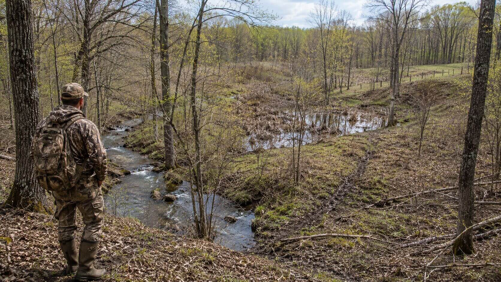
You’re looking at a 40-acre parcel Up North, standing in ankle-deep mud next to what the listing called a “seasonal creek.” The seller swore it was dry by October. But here in May, it’s running bank-to-bank, and you can see exactly why deer cross 200 yards downstream instead of where you planned to hang your stand. This is why serious buyers walk the ground in spring.
What Spring Conditions Reveal That Fall Conceals
![]() Actual Deer Movement Patterns Without Leaf Cover
Actual Deer Movement Patterns Without Leaf Cover
 Actual Deer Movement Patterns Without Leaf Cover
Spring offers the clearest view of how deer actually navigate your property.
Michigan’s 2025 deer harvest totaled 295,739 deer statewide, proving the state still supports strong whitetail populations, but you need to know where they move on your specific ground.
Without leaves blocking your view, you can trace deer trails from bedding to feeding areas in a single glance. Stand 200 yards away from what looks like a promising funnel and you’ll see if deer actually use it or simply walk around it. That oak ridge that seemed perfect during your October visit might reveal a parallel trail system 50 yards to the east that you never noticed.
Look for worn paths through CRP grass, muddy crossings at creek bottoms, and rub lines on mature timber. These patterns don’t lie — they show exactly where deer prefer to travel when hunting pressure isn’t pushing them into cover.
True Property Boundaries and Access Issues
Spring reveals boundary problems that cost buyers thousands. That “deeded access” through the neighbor’s property becomes obvious when you can see their No Trespassing signs from 400 yards away. Wet conditions also expose whether those “improved roads” actually provide reliable access or turn into impassable mud strips.
Walk every boundary line in May. You’ll find survey stakes that disappeared under October foliage, fence lines that don’t match the plat map, and easement disputes that sellers conveniently forgot to mention. Spring mud also shows which roads get county maintenance and which ones you’ll be grading yourself every year.
Water Sources and Wetland Boundaries
Michigan’s spring conditions reveal the true extent of wetlands that determine buildability and hunting quality. That “dry depression” from your fall walkthrough might actually be a jurisdictional wetland that limits where you can place food plots or build a cabin.
The March 2025 ice storm affected over 900,000 acres of state forest land in northern Michigan, altering drainage patterns across the region. Spring walkthroughs help identify how these changes affect water flow on properties within the storm zone.
Document every spring, seep, and seasonal pond. Use your phone’s GPS to mark water sources — they determine both deer activity and development limitations. Michigan wetland regulations can restrict activities within 100 feet of protected waters, making this information crucial for planning.
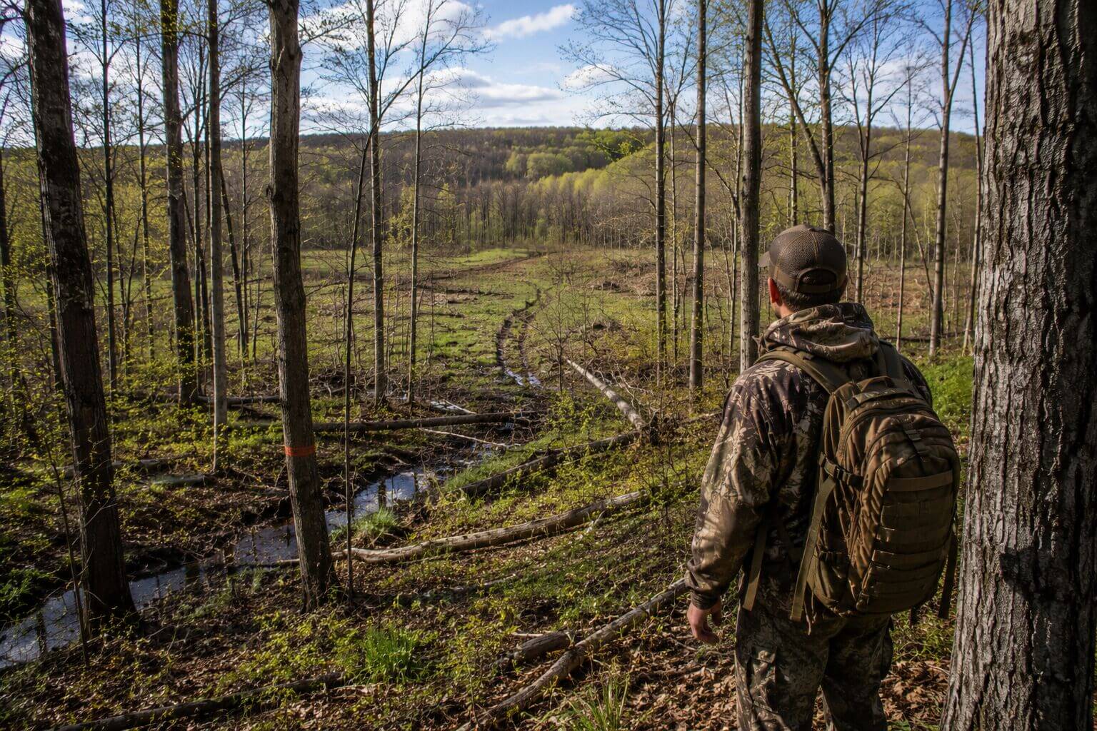
Reading the Timber: What May Shows About October Hunting
![]() Understory Density and Stand Placement Reality
Understory Density and Stand Placement Reality
 Understory Density and Stand Placement Reality
May’s bare understory reveals the truth about shooting lanes and stand visibility. That “perfect” tree you marked in October might offer 15 yards of visibility once multiflora rose and autumn olive leaf out. Spring shows exactly what you’ll be dealing with during hunting season.
Count how many trees you can see through at chest height. Mark potential stand trees that maintain good sight lines even with full foliage. Areas that look open in spring will become thick cover by October, affecting both your shooting opportunities and deer movement patterns.
Mast Production Potential
Spring buds tell you everything about fall food availability. Oak trees showing heavy bud development will likely produce strong acorn crops, while trees with sparse budding may have weak mast years. This information helps predict deer movement patterns months in advance.
Michigan’s red oaks produce acorns every other year, while white oaks can produce annually. A spring walkthrough reveals which trees are in production cycles and which areas will draw deer in fall. Mark producing trees on your GPS — they’re your primary hunting locations.
Storm Damage Assessment
Roughly 3 million acres of forest in 12 counties were affected by the 2025 ice storm, creating both problems and opportunities for hunters. Spring conditions show the full extent of damage that fall foliage might hide.
Look for stress fractures in damaged trees that could drop limbs during hunting season. But also identify new edge habitat created by blowdowns — these areas often become deer magnets as browse regenerates.
The DNR has focused on clearing fire-prone areas and main access roads used heavily by hunters, but many secondary access points remain blocked.
Evaluating Infrastructure and Development Potential
![]() Road Conditions Under Worst-Case Scenarios
Road Conditions Under Worst-Case Scenarios
 Road Conditions Under Worst-Case Scenarios
Spring mud reveals which roads handle heavy use and which ones trap vehicles. If you can’t drive your truck through in May, you won’t get a corn planter through in May or haul out a buck in November.
Test every road and trail in wet conditions. Mark sections that need drainage improvements or gravel. Factor road maintenance costs into your budget — some Michigan hunting properties require $2,000-3,000 annually in road work just to maintain access.
Building Site Evaluation
Spring water reveals ideal building sites and identifies areas to avoid. High ground that stays dry in May will handle a cabin or barn. Low areas showing standing water need expensive drainage solutions or should be avoided entirely.
Check for spring seeps that indicate year-round water issues. Test soil drainage by digging small holes — if they fill with water within an hour, you’re looking at potential foundation problems. Michigan’s clay soils hold water, making proper site selection critical.
Utility Access and Feasibility
Spring conditions help evaluate power line access and septic system viability. Bare trees reveal existing utility corridors and show whether bringing electricity to your building site requires expensive tree clearing.
Wet soils also indicate septic system limitations. Areas with standing water or saturated soils may not support conventional septic systems, requiring expensive alternatives like mound systems or holding tanks.
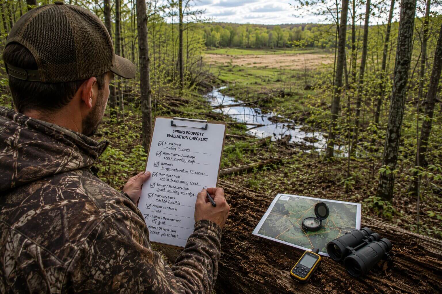
Spring Property Evaluation Checklist
![]() Essential Documentation Tasks
Essential Documentation Tasks
 Essential Documentation Tasks
Walk every boundary with GPS tracking enabled. Photograph corner markers and boundary evidence. Document any encroachments, fence lines that don’t match surveys, or access disputes. These issues become expensive problems if not identified before purchase.
Mark all water sources, including springs, streams, and seasonal wetlands. Note flow directions and estimate water volumes. This information affects both hunting quality and development restrictions under Michigan wetland laws.
Habitat Assessment Protocol
Count mast-producing trees by species and evaluate their health. Mark trees showing bud production for fall hunting planning. Identify damaged trees that need removal for safety or timber value.
Map deer travel corridors and bedding areas while visibility remains good. Mark trail intersections and natural funnels. These locations won’t be as obvious once leaves emerge, but they’ll determine your hunting success.
Infrastructure Documentation
Test every road in wet conditions. Document problem areas that need improvement. Calculate costs for necessary drainage, gravel, or bridge work. Many buyers underestimate road maintenance expenses by 50-75%.
Identify suitable building sites and mark them with GPS. Note drainage characteristics, access feasibility, and utility requirements. Spring evaluation prevents expensive mistakes during development.
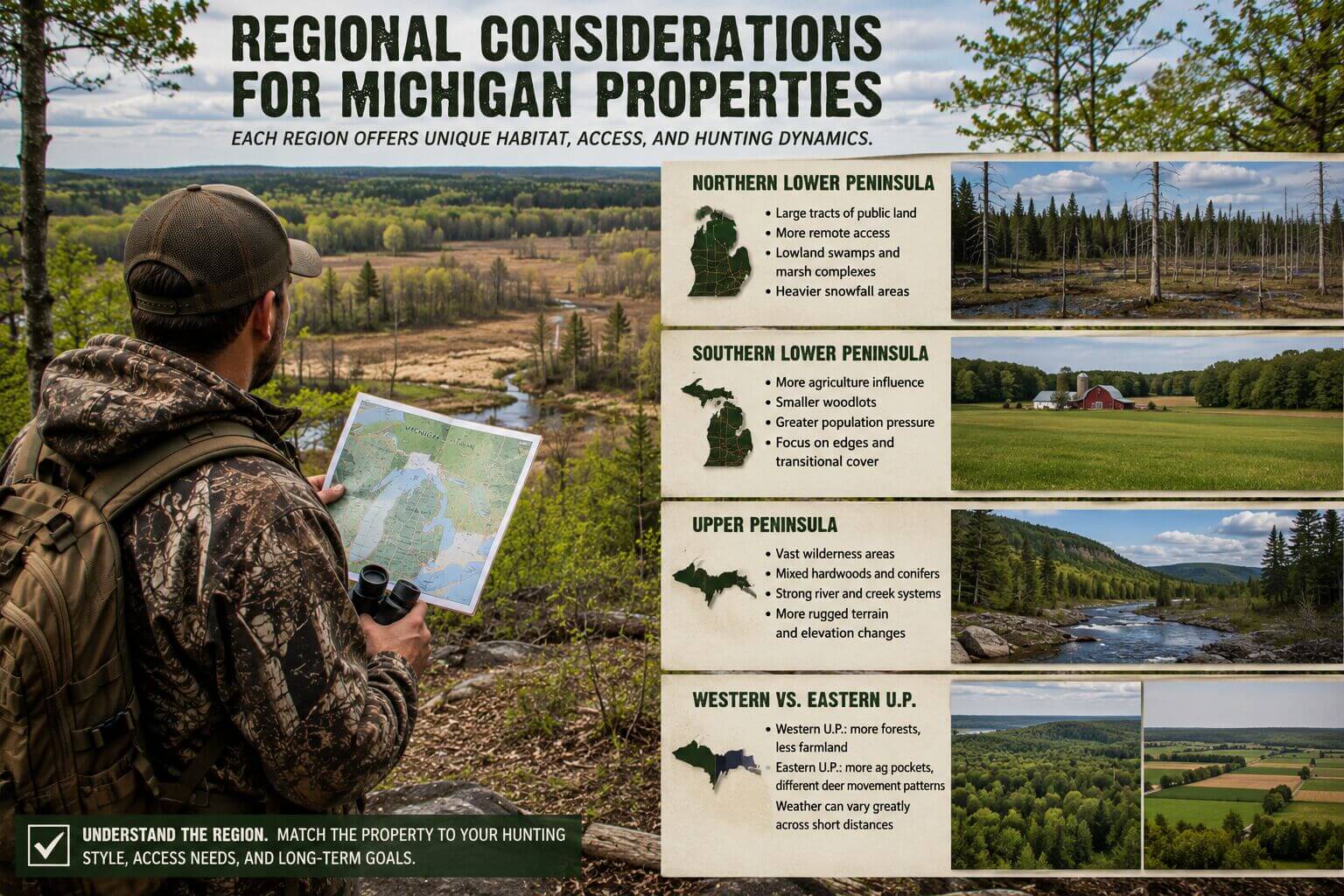
Regional Considerations for Michigan Properties
![]() Upper Peninsula Spring Challenges
Upper Peninsula Spring Challenges
 Upper Peninsula Spring Challenges
UP properties face unique spring evaluation challenges.
The UP deer harvest was down about 15 percent in 2025
due to winter impacts, making habitat quality assessment even more critical.
Snow may persist into May in some areas, limiting spring evaluation windows. Plan UP property visits for late May or early May when conditions allow full assessment. Focus on identifying winter survival habitat and evaluating timber quality.
Northern Lower Peninsula Ice Storm Impacts
Damage from the devastating March ice storm could limit access to hunting areas in northern Lower Peninsula counties. Properties within the storm zone require careful evaluation of ongoing damage and recovery potential.
The DNR cleared and opened all but 265 miles of roads within state forests, but private access roads may still have significant damage. Budget extra time and money for properties in affected counties including Alpena, Oscoda, Alcona, and surrounding areas.
Southern Lower Peninsula Disease Considerations
EHD has been confirmed in wild deer in at least 16 counties in southern Michigan, affecting deer populations and hunting quality. Spring scouting helps assess actual deer numbers versus expectations based on harvest data.
Look for signs of deer mortality or population impacts during spring walkthroughs. Areas heavily affected by EHD may show reduced sign and require different management strategies.