 Michigan hunting land aerial maps are detailed satellite or aircraft photographs that reveal terrain features, vegetation patterns, and property characteristics crucial for evaluating hunting potential before stepping foot on the ground. Unlike standard topographic maps, aerial imagery can illuminate obstacles, opportunities, and realities of the landscape in ways other maps cannot, with the ability to spot terrain traps, funnels, promising bedding areas, food and water sources from above.
In late 2025 reporting, Michigan was cited at $6,800 per acre on average, with a 7.8% increase year-over-year for farm real estate values, pushing serious buyers to scrutinize every detail before making offers. At Michigan Whitetail Properties, we’ve walked ground since 1995, and we’ll tell you this: the hunters who master aerial map reading before their property visits consistently make better buying decisions.
Purpose-built hunting properties are outperforming generic wooded acreage in today’s market, and aerials help you separate the two.
Picture this: You’re scrolling through listing photos of that 80-acre parcel Up North, seeing nothing but green trees and a creek. Looks perfect, right? But the aerial tells a different story — that creek becomes a swamp during spring rains, the “prime bedding area” is actually a low spot that floods, and the access road crosses three different property lines with questionable easement rights. We’ve seen buyers get burned on deals like this when they relied on listing photos instead of really studying the aerials.
How to Read Basic Features in Michigan Hunting Land Aerial Maps
Identifying Vegetation Patterns and Edge Habitat
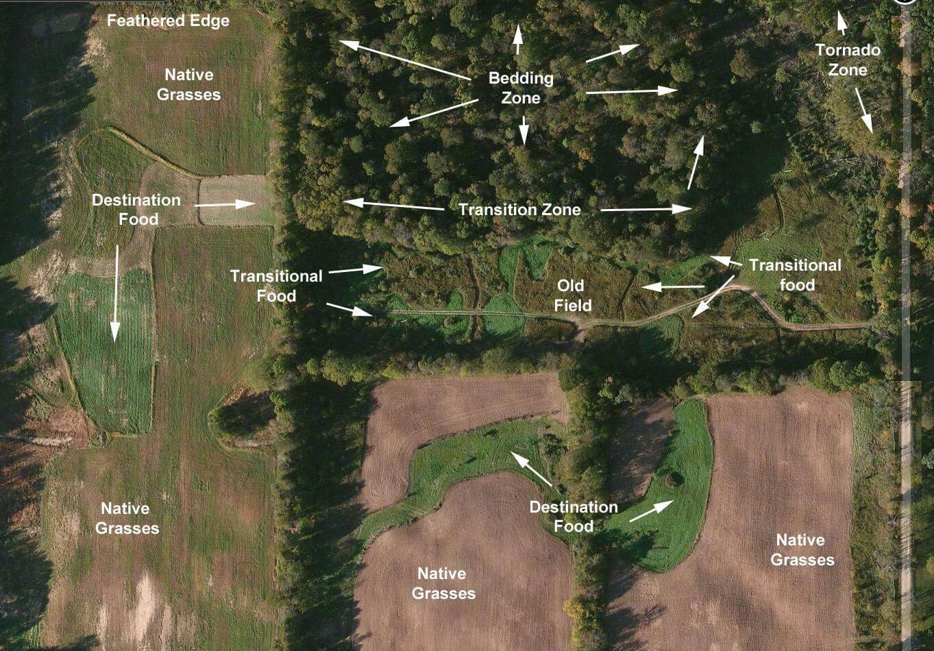 Aerial maps for deer hunting should tell you the tone, texture, shape, size, shadow, characteristics, and patterns of a landscape, and vegetation is where you start. In Michigan aerials, look for color variations that indicate different timber types. Dark green typically means mature hardwoods — your oak ridges and maple stands that produce mast crops. Lighter green often shows younger growth, recent clearcuts, or pine plantations.
But here’s what most buyers miss: the edges. Those irregular lines where dark green meets light green? Those are your money spots. Deer love transitional zones where mature timber meets young growth, agricultural fields, or openings.
Use contour spacing, map scale and legends together with aerial imagery and on-the-ground scouting to identify bedding areas, travel corridors and high-probability ambush sites.
In northern Michigan counties like Clare and Roscommon, pay attention to the contrast between planted pine blocks and native hardwood stands. The edges of those pine plantations, especially where they finger into creek bottoms, create natural funnels that concentrate deer movement.
Spotting Water Sources and Wetland Features
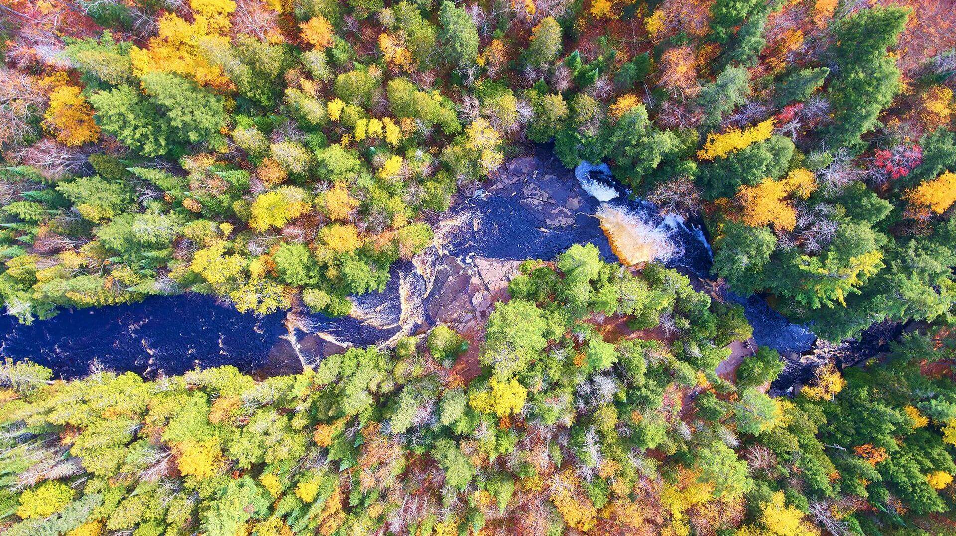
Water shows up dark in aerial photos, but not all dark spots are permanent water. Study the shape and setting. Round or oval dark areas in low spots are likely ponds or small lakes. Irregular, snaking dark lines following terrain contours indicate creeks or rivers. But those oddly-shaped dark patches in flat areas? Those could be seasonal wetlands that dry up by late summer — not exactly the year-round water source you’re hoping for.
Look for the gray-green areas surrounding water features. That’s typically cattail marsh or sedge, indicating wet soils. These zones can be gold mines for waterfowl hunting but might also mean access challenges during wet periods. We’ve seen hunters get excited about “waterfront property” that turned out to be swamp you can’t even walk through in October.
Reading Terrain and Elevation Changes
While aerials don’t show elevation lines like topo maps, you can still read the terrain through shadows and drainage patterns.
Learning to interpret the lines on a topo map is like learning to read a blueprint of the land before you step foot in it, and aerials provide the real-world context for those blueprints.
Ridges cast shadows, and you can often see the shadowed (north-facing) slopes appearing darker than sun-exposed (south-facing) slopes. Creek beds create distinct patterns as they wind through terrain, showing you the natural lay of the land. Look for where small drainages converge — these are natural travel corridors for wildlife.
What Aerial Maps Reveal About Deer Movement and Bedding
Finding Natural Funnels and Pinch Points
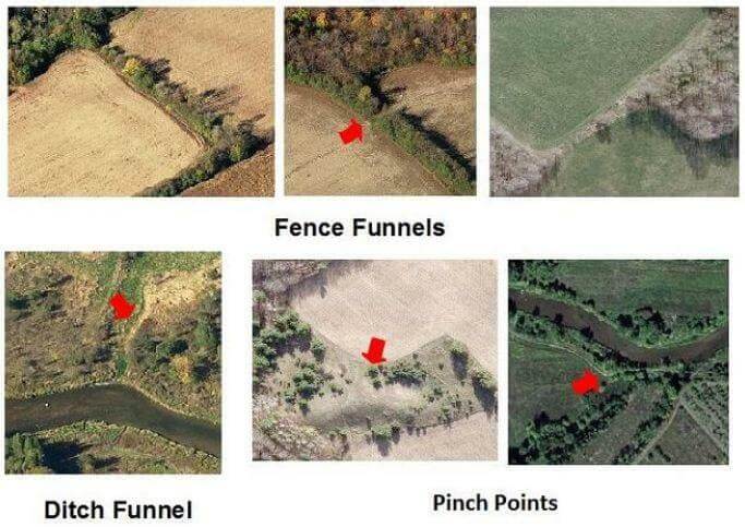 These pinch points concentrate movement much like a bottleneck funnels water, guiding deer along the easiest, most sheltered path. By methodically mapping these funnels and linking them to broader corridors such as creek bottoms, ridge trails, field edges or old logging roads, you transform a large area into a handful of high-traffic hotspots.
From above, funnels look like narrow connections between larger habitat areas. Maybe it’s a strip of timber connecting two woodlots across an agricultural valley. Or a creek bottom that threads between two ridges. In Michigan’s farm country — think Calhoun, Eaton, and Ingham counties — look for fence lines, woodlots, and drainage ditches that create natural highways between bedding and feeding areas.
The key is proportion. A 40-yard-wide creek bottom connecting a 500-acre timber block to a 200-acre cornfield? That’s a funnel worth your attention. A 200-yard-wide lowland between two small woodlots? Probably not concentrated enough to be consistently productive.
Identifying Likely Bedding Areas from Above
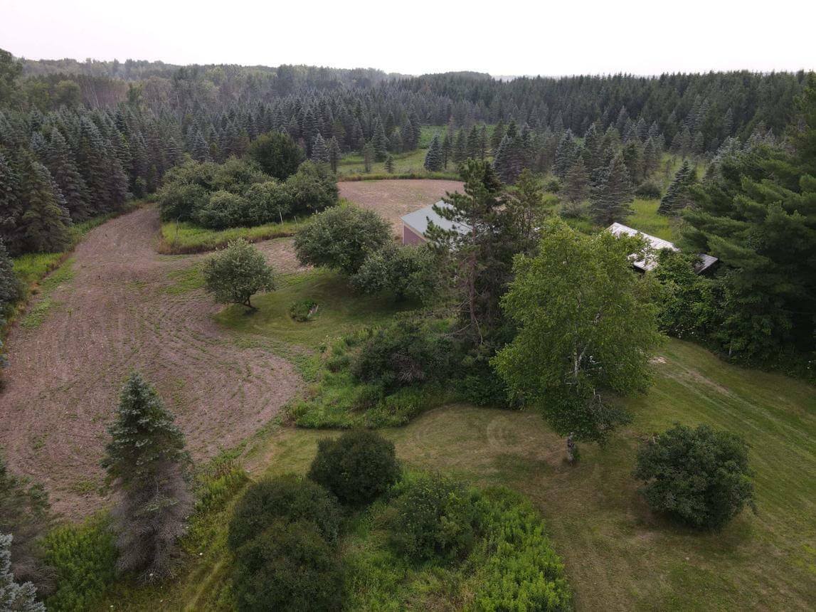
Bedding cover has a distinct signature in aerial photos once you know what to look for. Dense, continuous canopy that appears dark and uniform often indicates thick security cover — the kind of stuff deer want to bed in. But the magic happens at the edges of that thick cover, especially where it meets openings or changes elevation.
Look for irregular patches of slightly lighter green within the dark timber. These often indicate small openings, blowdowns, or natural clearings within the timber that create micro-habitats. Deer frequently bed on the edges of these internal openings where they can see out while staying hidden.
In Northern Lower Peninsula counties like Otsego and Montmorency, pay special attention to the transition zones between planted pine and native hardwoods. These areas often show up as mixed-tone patches in aerials and can hold incredible bedding habitat.
Recognizing Food Sources and Agricultural Patterns
Farm fields are obvious in aerial photos, but reading the patterns tells you more about hunting potential.
In Michigan, statewide averages reported in farm media covering USDA data pegged non-irrigated cropland rent around $143/acre, which gives you a sense of productive agricultural ground.
Look at field shapes and their relationship to timber. Long, narrow fields create more edge habitat than square fields of the same acreage. Fields that extend finger-like projections into timber create natural staging areas where deer feel comfortable feeding close to cover.
Study the field patterns across multiple years if you can access historical imagery. Fields that have been in corn for several consecutive years might indicate a farmer who consistently plants deer-friendly crops. But fields that alternate between different crop types show management flexibility that might work in your favor as a neighboring landowner.
Hidden Access Issues and Red Flags in Aerial Photos
Spotting Easement and Right-of-Way Problems
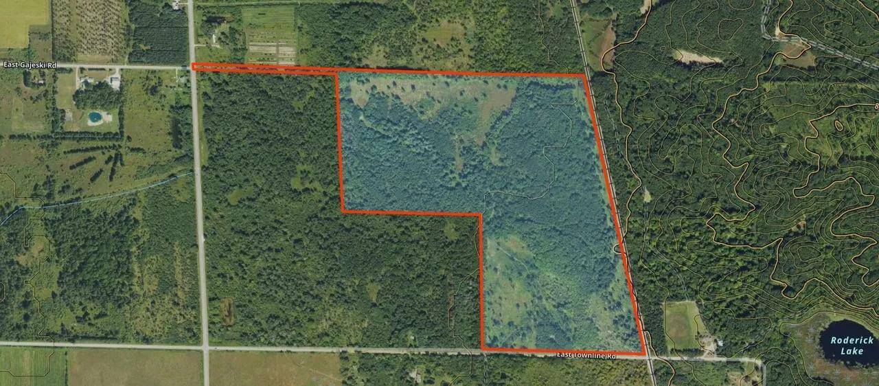 This is where aerial maps can save you from expensive mistakes. That nice gravel road leading to the property? Trace it back to the public road. Does it cross other properties? Those crossings need legal easements, and many hunting property listings don’t adequately address access rights.
Look for places where the access route makes sudden turns or jogs around obstacles. These often indicate property line issues or easement restrictions. A straight road that suddenly veers around a small patch of timber or structure might signal an easement dispute or limitation you need to investigate.
Pay attention to road width and surface conditions visible in the aerial. A well-maintained gravel road suggests established access rights and ongoing maintenance agreements. A faint two-track that disappears in places might indicate seasonal access or disputed rights-of-way.
Identifying Neighboring Land Use Concerns
Aerial imagery and topographic maps reveal the subtle rises and falls in terrain, while on-the-ground scouting confirms worn trails, rubs and scrapes, but they also reveal potential conflicts with neighboring land use.
Look beyond your property boundaries at what surrounds your potential purchase. That nice 40-acre timber lot might look perfect until you notice the gravel pit operation visible in the aerial just to the north. Or the residential development with houses backing up to your potential southern boundary.
Pay attention to industrial facilities, confined animal feeding operations, or other land uses that might impact your hunting experience. These show up clearly in aerial photos but might not be mentioned in property listings.
Recognizing Seasonal Access Challenges
Michigan’s seasonal access challenges often show up in aerial photos if you know what to look for. Those dark, low-lying areas that might look like simple wetlands could be seasonal flooding zones that make spring access impossible. Creek crossings that look fine in late-summer aerial photos might be impassable during spring thaw or after heavy rains.
Study the relationship between your access route and water features. Does the road cross multiple creek beds or low-lying areas? These could become bottlenecks during wet periods. Look for alternative routes or higher ground that might provide year-round access.
Using Modern Aerial Tools and Technology
Leveraging Multiple Imagery Sources
 Recent Imagery gives you the insight of comparing what lands look like now versus before. With medium-resolution (5-meter) maps available for every two weeks prior (currently back to March 2023) you can track changes over time. Use Recent Imagery to monitor changing snow lines, thawing bodies of water, field cuts, timber thinning, wildfires or prescribed burns.
Don’t rely on just one aerial image source. Google Earth provides historical imagery that lets you track changes over time. County GIS systems often provide more recent, higher-resolution photos. USDA’s Web Soil Survey includes aerial photos with soil data overlays that can help you understand drainage and productivity patterns.
Compare aerials from different seasons when possible. Spring photos with no leaves on deciduous trees reveal terrain features and infrastructure hidden by summer foliage. Fall photos show mast-producing trees and crop harvest patterns. Winter aerials can reveal travel patterns and access challenges.
Understanding Leaf-Off vs. Leaf-On Imagery
Leaf-Off Imagery shows landscapes captured when trees have shed their leaves, revealing trails, creek beds, and game movement areas normally hidden by foliage. This type of imagery is invaluable for Michigan hunting land evaluation.
Leaf-off photos let you see through the canopy to identify internal trails, creek beds, and terrain features that summer photos hide. You can spot old logging roads, fence lines, and even building foundations that might not be visible during growing season. These hidden features often become key components of deer movement patterns.
Winter aerial photos also show how snow accumulates and melts on different aspects of the property, giving you clues about thermal patterns and preferred deer bedding areas during harsh weather.
Integrating Topographic Data with Aerial Images
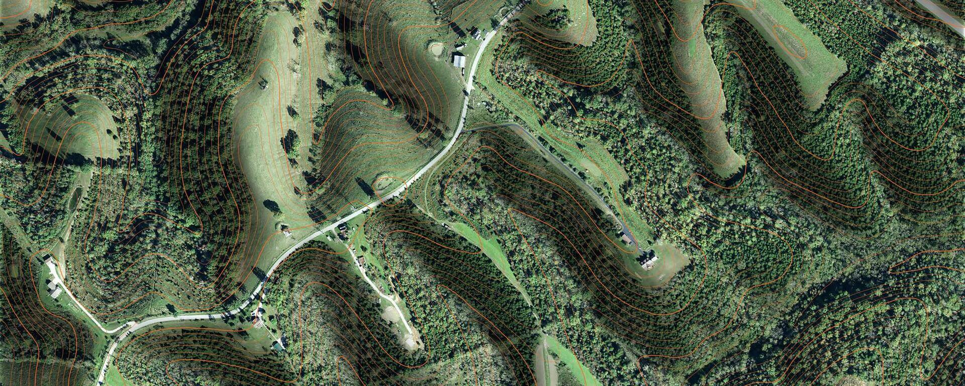
The Hybrid Basemap is a mix of Aerial and Topo, where contour lines overlay satellite imagery. The combination results in a highly functional display of the landscape to give hunters a clear view. The Hybrid Basemap presents users with the information needed to make important decisions about where they want their hunt to take them.
Modern mapping applications let you overlay topographic contours on aerial photos, combining the visual detail of aerial imagery with the elevation data of topo maps. This combination reveals the relationship between vegetation patterns and terrain features that drives deer behavior.
Look for spots where terrain features visible in the topo lines match vegetation patterns visible in the aerial. For example, a saddle between two ridges (visible in topo lines) that also shows lighter vegetation or a natural opening (visible in aerial) is likely a heavily used travel corridor.
 Understanding Michigan hunting land aerial maps transforms you from a hopeful buyer into an informed investor.